THE ULTIMATE GUIDE TO CLIMBING UKRAINIAN’S HIGHEST MOUNTAIN
2018-12-04 14:36:20
It’s always exciting to stand on the highest spot of something (mountain’s massif, country or Earth). Speaking about Ukrainian highest point, it brings us to the Carpathian Mountains in the western part of the country. Mt. Hoverla with height 2061 m is considered as the highest top of Ukraine and it is located among the others two-thousandths meters peaks on Chornohora range. In this article, you are going to find out about different ways to get to the highest point of Ukraine.
There are several starting points from which you can reach the top of Mt. Hoverla. From almost all of them, it takes more than 1 day of hiking to get to the top. We are going to explore the most accessible spot and closest to the summit, called Zaroslyak. It is a high mountain sports training resort near the town of Vorokhta.
So, how to get to Zaroslyak from Lviv city and to reach the summit? The easiest way, of course, is to do it by car. But there is also an opportunity to make it by bus or by train. Let’s take a brief look at the ways of climbing the highest Ukrainian mountain.
Make it by car
Going to Zaroslyak from Lviv by car will take about 4-5 hours of driving. The distance is about 250 km. The last 20 kilometers of the road from Vorokhta to Zaroslyak are in bad shape.
From Lviv, you have to take south-western direction to Ivano-Frankivsk. After Ivano-Frankivsk keep going on the south, looking for signs to Yaremcha, Verkhovyna, Vorokhta. The best advice for you is to get navigator for a car or use one in your cell phone. But even without it you can find a paper road map in any bookstore or try to get the orientation with Road Signs.
6 km after Vorokhta town you will have to turn right from the main road near the sign pointing to Zaroslyak. And from there just keep going straight forward all the time until you will reach final point.
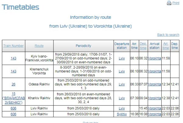
Make it by train
There are several trains connecting Lviv with Vorokhta. Time on the road will take from 4 and a half hours to 6 hours, depends on a train. It’s better to take a morning train, so you don’t need to look for accommodation in Vorokhta or Zaroslyak for a spending night. You can book your train tickets here: booking.uz.gov.ua/en
From Vorokhta you will have to ask for a transfer to Zaroslyak. You can easily find one just at the train station or nearby it. Ask any taxi driver or any local and they will help you immediately. The price of the transfer is about 250-400 grn. for the car, so if you are a group of people you can share it between all of you. If you are alone, try to find other people who also need to reach Zaroslyak.
Make it by bus
There are not so many straight buses from Lviv to Vorokhta. But few of them you can find in Lviv Bus Station № 8 just near the main train station. They take about 6 hours to reach Vorokhta town from Lviv. You can buy your bus tickets online here (http://ticket.bus.com.ua/?lang=en) or at the bus station.
From Vorokhta to Zaroslyak you will need to take a transfer (how to do it is described in previous section little bit above).
An option of combining transports
It is also a good way to reach Zaroslyak by combining different kinds of transportation. You can take a train or bus from Lviv to Ivano-Frankivsk which is much easier to catch at any time of the day. And from Ivano-Frankivsk to Vorokhta you need to take a bus with direction to Verkhovyna.
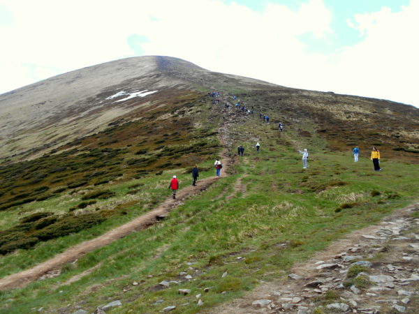
Hiking routes to Mt. Hoverla (2061m)
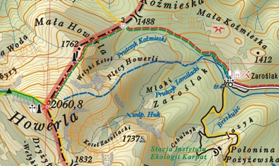
The most popular touristic trails to the top of Hoverla start from Zaroslyak.
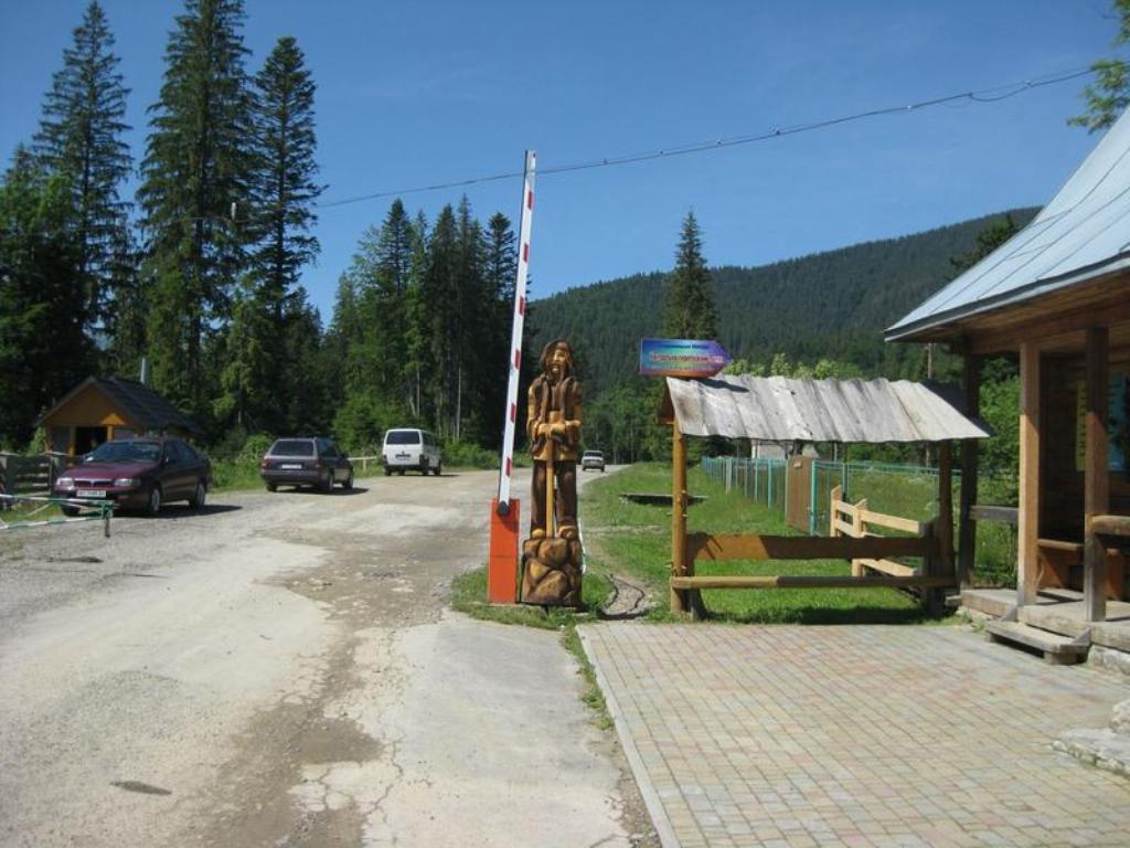
photo from https://blog.karpaty.rocks/pishyy-turyzm/marshrut-na-goverlu-vid-bazy-zaroslyak
The other option is a green marked hiking trail which is approximately 1 km longer than the blue one. It is more aslope, so if you prefer to walk slowly, taking your time, pick this one.
Elevation between Zaroslyak and Hoverla is not that big (a little bit more than 700 m).
One more detail you might need to know. Mt. Hoverla lies on the territory of Carpathian Biosphere Reserve. So, when you enter this territory they will ask you to pay approximately 1 euro.
Good luck in climbing the highest top of Ukraine.
Your Active Ukraine team

Travel with us
Join thousands of travelers, who explored Ukraine with our adventure, cultural or heritage tours since 2011.Trusted by National Geographic, BBCW, Wild Frontiers and others.
Ask us anything